Grande Cammino della Brigantessa
Caratteristiche del Cammino
∙N.Tappe : 5
∙Distanza: Circa 80,0 km, e 3504m. di dislivello positivo.
∙Tempo di percorrenza: 5 giorni
∙Difficoltà: media.
∙Ambiente: Le tappe attraversano boschi di castagno e faggio, aree prative, panorami mozzafiato e 10 borghi.
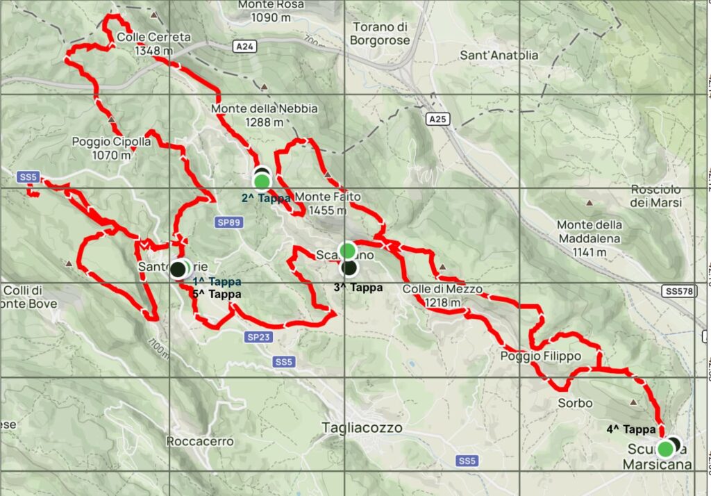
Il Grande Cammino della Brigantessa è un affascinante percorso che si snoda per 86 km attraverso i paesaggi incantevoli dell’Abruzzo, partendo da Sante Marie (AQ) e attraversando luoghi ricchi di storia e cultura. Con un dislivello positivo di 3504 metri, questo cammino offre un’esperienza unica, immersa nella natura e nella tradizione.
La partenza avviene a Sante Marie, noto come il paese del Cammino dei Briganti e dei Murales. Qui, i visitatori possono ammirare opere d’arte che raccontano storie di briganti e della vita locale. Da qui, il percorso si dirige verso Tremonti, il primo centro abitato che si incontra, dove si possono
respirare le tradizioni locali.
Proseguendo, il cammino entra nella Riserva Naturale Regionale delle Grotte di Luppa, un’area di straordinaria bellezza naturale. Qui, si viene avvolti da boschi rigogliosi e panorami mozzafiato, che conducono a Castelvecchio. Questo pittoresco borgo, con le sue antiche mura e il suo fascino
caratteristico, rappresenta un’importante tappa del percorso. Continuando, si intercetta il sentiero dei Briganti, che conduce a Valdevarri, un luogo di grande significato storico, poiché qui visse Tommaso da Celano, il primo biografo di San Francesco. Questo borgo offre una pausa riflessiva, immersi nella storia e nella spiritualità.
Da Valdevarri, il cammino si snoda attraverso sentieri e strade che portano al borgo di Santo Stefano. Qui, i camminatori possono prepararsi per la salita al Monte Faito, il punto più alto del percorso, che svetta a 1410 metri. La vista dalla cima è spettacolare, offrendo uno sguardo panoramico sui dintorni e un
senso di conquista.
Dopo aver ammirato il panorama, si scende verso la frazione di Scanzano, che si attraversa prima di dirigersi verso Scurcola Marsicana. Questa località è nota per il suo ricco patrimonio storico, e culturale in particolare per il Castello degli Orsini, che domina il paesaggio circostante.
Infine, da Scurcola Marsicana, il cammino riporta a Sante Marie attraverso una lunga e suggestiva tappa . Durante il percorso, si attraversano borghi affascinanti come Tubione, il centro più piccolo del cammino con soli tre residenti, e San Giovanni, da dove è possibile ammirare la meta finale.
Il Grande Cammino della Brigantessa non è solo un percorso fisico, ma un viaggio che esplora la storia, la cultura e la bellezza naturale della regione, unendo le tradizioni dei briganti con la spiritualità e il patrimonio loca.
Sante Marie – Sante Marie
Prima tappa
Caratteristiche Tappa
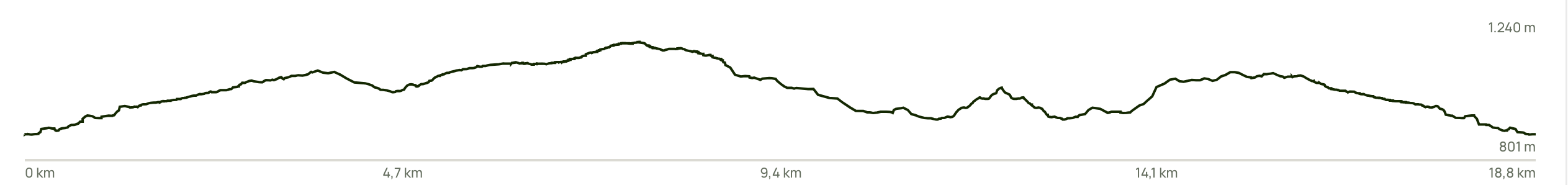
∙Distanza: Circa 18,9 km, e 829 m. di dislivello positivo.
∙Tempo di percorrenza: Stimato tra 6H:30’ 6H:45’, a seconda delle soste e del ritmo di cammino.
∙Difficoltà: media, con tratti impegnativi di salita.
∙Ambiente: La tappa attraversa boschi di castagno e faggio, aree prative e panorami mozzafiato.
Questa prima tappa del percorso inizia da Piazza Aldo Moro, proprio di fronte al murales dedicato alla Brigantessa Nicolina De Cesare. Ci si snoda per circa trecento metri lungo via Roma, dove è possibile ammirare una serie di murales che raffigurano opere d’arte in stile popolare, rappresentando icone della storia, delle tradizioni e scene di vita rurale, oltre a evocare il tema del brigantaggio in Abruzzo.
Dopo aver contemplato questi bellissimi murales, continuiamo il cammino svoltando leggermente a destra su via della Resistenza, che lasciamo dopo un centinaio di metri. Al bivio, svoltiamo a destra su via Boccavalle, fino a raggiungere uno slargo con una croce sulla destra, da cui si apre un magnifico panorama sul borgo di Sante Marie.
Proseguendo, giungiamo a un bivio con il Sentiero Corradino, dove svoltiamo a sinistra; un leggero pendio ci conduce a una carrareccia immersa in un castagneto. Superata un’abitazione sulla sinistra, intercettiamo un bivio dove svoltiamo nuovamente a sinistra. Superate altre abitazioni in costruzione, ci uniamo al sentiero “singol trek” che ci porterà al centro residenziale denominato le Piccole Dolomiti.
Attraversando alcune case, svoltiamo a destra e seguiamo la carrareccia seguendo le indicazioni del Cammino, che si sovrappone a quello di San Quirico.
Questo tratto si sviluppa all’interno della Riserva Naturale Regionale delle Grotte di Luppa, fino a raggiungere la chiesetta di San Quirico, un autentico gioiello rupestre immerso nella natura e dedicato al Santo patrono di Sante Marie. Ma le sorprese non finiscono qui: il sentiero prosegue verso la “Panchina Gigante”, da cui si possono ammirare scorci unici sui monti del Parco Regionale Sirente-Velino e sulla Riserva Naturale della Duchessa, fino a intravedere all’orizzonte i monti del Parco Nazionale d’Abruzzo.
Proseguendo, raggiungiamo la “Chiesetta degli Alpini” e, dopo circa 1,5 km, arriviamo al borgo medievale di Tremonti, dove faremo una breve sosta per rifornirci d’acqua. Da Tremonti, seguendo la segnaletica, ci dirigiamo attraverso splendide praterie e fitti boschi verso la “Fonte della Rocca”, dove possiamo approfittare di una sosta ristoratrice nell’area picnic della Riserva Regionale Grotte di Luppa.
Successivamente, lungo un incantevole single trek, raggiungiamo la Grotta di Luppa. Da qui, torniamo indietro sullo stesso tracciato fino al bivio con il sentiero che ci condurrà alla “Grotta del Tesoro”, per poi ritornare nuovamente alla Fonte della Rocca e, infine, proseguire fino a Sante Marie, dove si conclude la prima tappa.
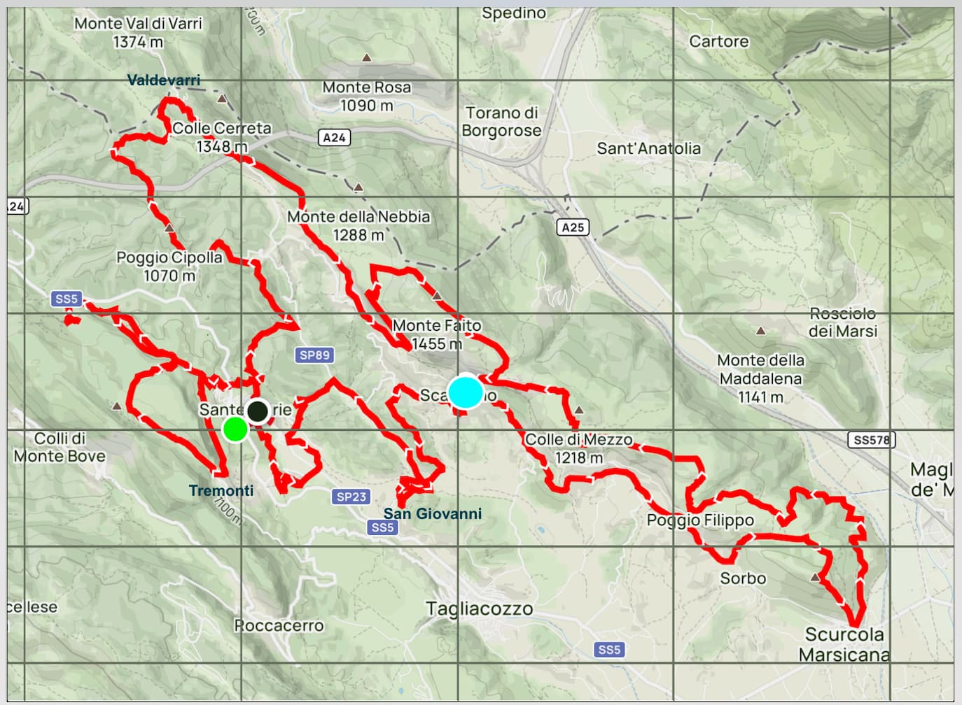
Sante Marie – Santo Stefano
Seconda tappa
Caratteristiche Tappa
∙Distanza: Circa 17,2 km, e 723 m. di dislivello positivo.
∙Tempo di percorrenza: Stimato tra 5H:15’ 5H:30’, a seconda delle soste e del ritmo di cammino.
∙Difficoltà: media, con tratti impegnativi di salita.
∙Ambiente: La tappa attraversa boschi di castagno e faggio, aree prative e panorami mozzafiato.
Si parte, come nella prima tappa, da Piazza Aldo Moro, dinanzi al murales dedicato alla Brigantessa Nicolina De Cesare, simbolo di questo Cammino. Da qui, imbocchiamo Via della Resistenza e, dopo circa 150mt al bivio, svoltiamo a destra su Via Boccavalle fino a raggiungere uno slargo con una croce in ferro posta alla nostra destra destra, da cui si può ammirare un bellissimo panorama sul borgo di Sante Marie e sulla vallata sottostante.
Subito dopo, giungiamo al bivio con il Sentiero Corradino, dove svoltiamo a destra e ci accavalliamo con il sentiero Corradino, fino a raggiungere il centro abitato di Castelvecchio, frazione di Sante Marie.
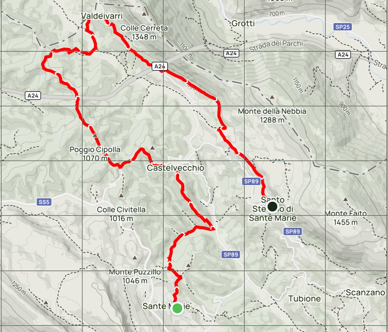
Le origini di Castelvecchio risalgono a tempi antichi, e il borgo è caratterizzato da una storia ricca e affascinante, influenzata dalla sua posizione strategica nel cuore dell’Appennino.
La zona è nota per la presenza di insediamenti risalenti all’epoca romana, ma Castelvecchio si sviluppò principalmente durante il Medioevo, periodo in cui furono costruite numerose fortificazioni e castelli per difendersi da invasioni e conflitti. Il nome “Castelvecchio” suggerisce infatti la presenza di una struttura fortificata, utilizzata come punto di controllo e protezione per gli abitanti locali.
Nel corso dei secoli, il borgo ha mantenuto il suo fascino medievale, con stradine strette e case in pietra che raccontano la storia della comunità. La chiesa principale, dedicata a San Giovanni Battista, rappresenta un esempio dell’architettura religiosa tipica della regione. La posizione collinare di Castelvecchio offre anche splendidi panorami e opportunità per varie attività all’aperto, come escursioni e passeggiate nella natura circostante.
Tra le manifestazioni locali, è da menzionare la Sagra del fungo porcino di Castelvecchio, organizzata a metà agosto dalla Pro Loco del paese.
Attraversato Castelvecchio, ci inoltriamo per circa 1,5 km su una strada asfaltata , Via Fontanile, che poi lascimo per svoltare a destra , per seguire un fantastico sentiero che si snoda tra boschi di castagni e faggi, regalando panorami mozzafiato fino a raggiungere il centro di Valdevarri, una frazione del comune di Sante Marie.
Questo luogo ha una connessione storica significativa con il Beato Tommaso da Celano, un importante religioso e scrittore del XIII secolo. Infatti, Tommaso visse e morì nel convento delle Clarisse di Valdevarri, che rappresenta uno dei luoghi in cui trascorse gli ultimi anni della sua vita, dedicandosi alla preghiera e alla scrittura.
Fondato nel XIII secolo, il convento delle Clarisse è un esempio di architettura religiosa e vita monastica. Qui, Tommaso scrisse alcune delle sue opere più importanti e continuò a diffondere il messaggio di San Francesco. La sua morte, avvenuta intorno al 1260, segna la fine di una figura cruciale del francescanesimo, fondamentale per la diffusione della spiritualità di San Francesco.
A Valdevarri, è possibile ristorarsi e fare rifornimento d’acqua presso la fontanella del paese. Proseguendo il nostro viaggio verso Santo Stefano, ci immettiamo sulla strada frequentata solo dai residenti, Via Valdevarri, per 1,5 km, per poi imboccare sulla sinistra il sentiero che, dopo circa 4 km, ci porterà alla fine della seconda tappa a Santo Stefano.
Santo Stefano-Monte Faito-Scanzano
Terza tappa
Caratteristiche Tappa
∙Distanza:Circa 9,8 km, e 600 mdi dislivello positivo.
∙Tempo di percorrenza: Stimato tra 4H:15’ 4H:45’, a seconda delle soste e del ritmo di cammino.
∙Difficoltà:media ,con tratti impegnativi di salita fino a raggiungere Monte Faito 1455 m. disces tra prati e sentieri traversi .
∙Ambiente: La tappa attraversa boschi di faggio, aree prative e panorami mozzafiato.
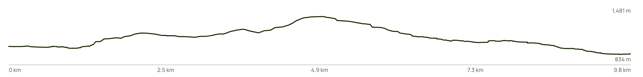
La terza tappa del cammino, caratterizzata dall’ascesa a Monte Faito, rappresenta un’esperienza emozionante per gli amanti della natura e dell’escursionismo.
Con un’altitudine di 1455 metri, rappresenta la vetta più alta del cammino. Monte Faito, offre panorami mozzafiato che si estendono su tutto l’Appennino abruzzese. Durante l’ascensione, i camminatori possono godere di un paesaggio variegato, con boschi di faggi, prati fioriti e la possibilità di avvistare la fauna locale. La tranquillità e la bellezza del percorso rendono questa tappa speciale, permettendo di immergersi completamente nella natura.
Una volta raggiunta la cima, le vedute sono straordinarie: è possibile vedere le cime delle montagne circostanti, Il Monte Velino ,in lontananza il Monte Terminillo , per non parlare della Maiella, dei Monti del Parco Nazionale d’Abruzzo e Molise e dei Monti Simbruini.
La vista panoramica rappresenta un momento di grande soddisfazione per i camminatori, che possono riflettere sul percorso fatto e sull’impegno profuso. Inoltre, Monte Faito ha una significanza storica e culturale, essendo un luogo di passaggio e di riferimento per gli abitanti della zona. È anche un ottimo punto per fare fotografie, raccogliere ricordi e apprezzare la bellezza naturale dell’Abruzzo.
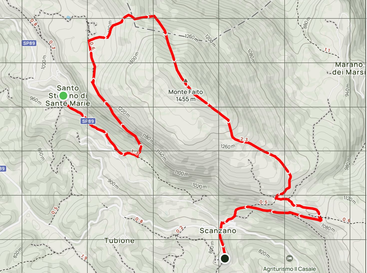
Veniamo al percorso , lasciamo il borgo di Santo Stefano , il cui territorio possiede una storia ricca che risale all’epoca preromana e romana, quando era abitato dagli Equi.
Nella località montana nota come Le Colonnelle si trovava uno dei confini degli Albensi, documentato da una lapide con l’iscrizione “Albensium fines”, rinvenuta nella vicina val de’ Varri e conservata nella chiesa di Santa Maria a Scanzano.
Le prime attestazioni storiche dell’abitato moderno risalgono al 1188, quando Papa Clemente III menzionò nella sua bolla la “ecclesia Sancti Stephani in Caprili” al vescovo Eliano, evidenziando la presenza di una chiesa connessa a un cenobio benedettino.
Anche dopo la scomparsa dei religiosi, questa chiesa rimase un simbolo della vita monastica e costituì il nucleo attorno al quale si svilupparono le prime forme insediative moderne, dando origine al toponimo “Santo Stefano.” Questo patrimonio storico e culturale rappresenta una parte significativa della tradizione locale e della storia della regione.
Attraversato il centro di Santo Stefano, sulla strada asfaltata, arriviamo davanti al cimitero del paese , qui prendiamo sulla sinistra il sentiero che ci porta agli scavi archeologici di Scanzano, prima dei quali sulla nostra sinistra imbocchiamo il sentiero a metà costa che ci porterà sul punto di intersezione di una carrareccia raggiunto il quale piegheremo a destra seguendo la segnaletica , che tra radure e boschi di faggio ci porterà sulla vetta di Monte Faito contraddistinta da una grande croce in ferro.
Da qui prenderemo l’evidente sentiero che ci porterà a raggiungere il bivio con la carrareccia proveniente da San Donato di Tagliacozzo, gireremo a destra e dopo una ripida discesa giungeremo alla fine della nostra terza tappa nel centro di Scanzano.
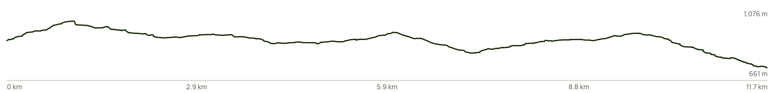
Scanzano – Scurcola Marsicana
Quarta tappa
Dal centro di Scanzano seguendo il la segnaletica del percorso e entrando in sovrapposizione con quello del Cammino dei Briganti che lasceremo alla nostra destra appena giungeremo al primo bivio ( circa 1Km) e dove troveremo la nostra indicazione scendiamo su un comodo sentiero verso il centro abitato di San Donato, subito dopo il 3° Km svolteremo leggermente a destra e prendiamo una strada asfaltata per 800m (Via Aldo Moro) che ci farà attraversare San Donato e che lasceremo svoltando a destra su una stradina sterrata (via Nazzario Sauro ) che lasceremo circa dopo 200m svoltando a sinistra dove percorreremo per circa 800m la Strada Provinciale 89 fino al bivio con un sentiero che imbocchiamo alla nostra sinistra , che ci seguiremo fino a Scurcola Marsicana , lambendo al 6°Km la frazione di Poggio Filippo per poi continuare fino al centro di Scurcola Marsicana dove termina la 4^ tappa del Cammino.
Caratteristiche Tappa
∙Distanza:Circa 11,8 km, e 409 m di dislivello positivo.
∙Tempo di percorrenza: Stimato tra 4H:00’ 4H:30’, a seconda delle soste e del ritmo di cammino.
∙Difficoltà: Il percorso è considerato di difficoltà media, con tratti asfaltati e sterrati.
∙Ambiente: La tappa attraversa boschi di castagno e faggio, aree prative e panorami mozzafiato.
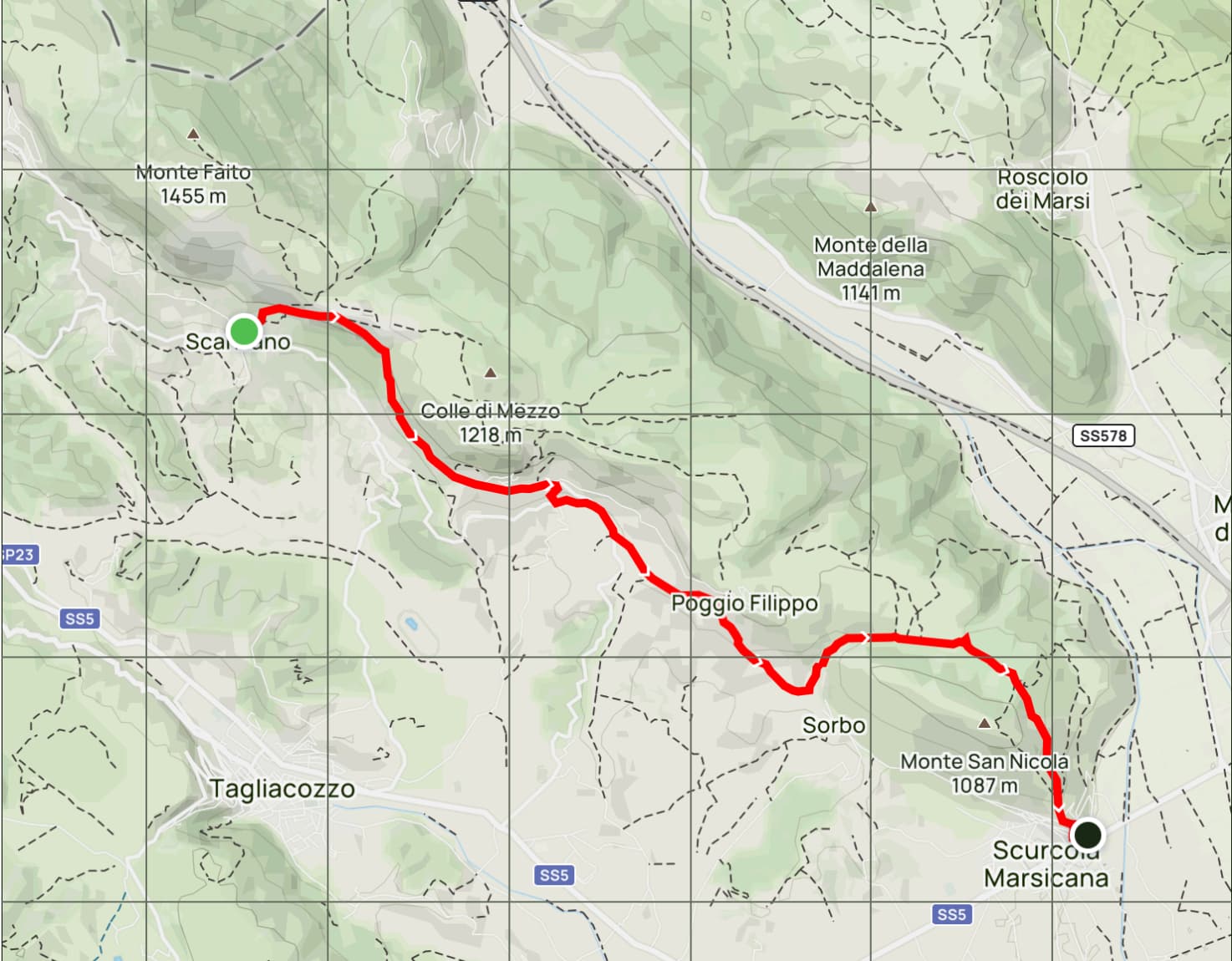
- Luoghi di interesse: diversi i luoghi di interesse interessati da questa tappa e soprattutto nel comune di Scurcola Marsicana. Tra questi :
- Chiesa della Santissima Trinità: Questa chiesa madre è famosa per la sua scalinata barocca. L’interno è decorato con opere artistiche locali e offre un’atmosfera di grande spiritualità.
- Chiesa di Santa Maria della Vittoria: Oltre alla statua della Madonna della Vittoria, la chiesa è un importante esempio di architettura religiosa medievale. È un luogo di culto molto venerato dai locali, soprattutto durante le feste religiose
- Rocca Orsini: fortilizio rinascimentale dalla particolare forma triangolare
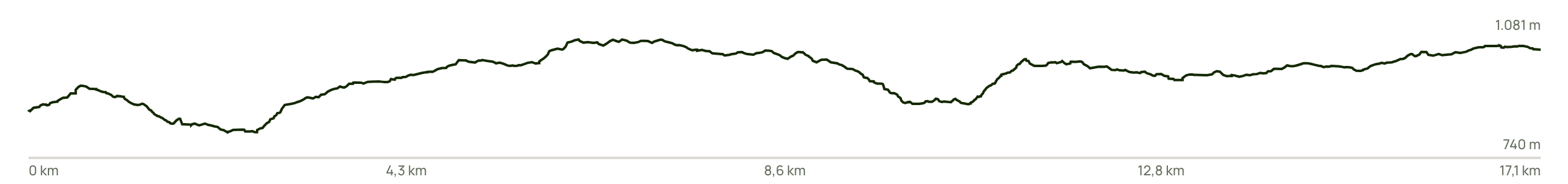
Scurcola Marsicana – Sante Marie
Quinta tappa
Caratteristiche Tappa
∙Distanza: Circa 23,1 km, e 943 m di dislivello positivo.
∙Tempo di percorrenza: Stimato tra 7H:30’ 7H:45’, a seconda delle soste e del ritmo di cammino.
∙Difficoltà: impegnativo, con tratti impegnativi di salita.
∙Ambiente: La tappa attraversa il centro abitato di Scurcola Marsicana boschi di pino, aree prative e panorami mozzafiato.
Questa tappa parte dal centro di Scurcola Marsicana, Chiesa della Santissima Trinità, attraversa una parte di Corso Emanuele III, per prendere la prima scalinata a sinistra e salire tra le storiche stradine del centro storico fino a raggiungere il Castello Orsini o Rocca Orsini dal quale non seguiremo il sentiero che porta a Monte San Nicola, ma prenderemo la comoda e panoramica carrareccia sulla destra fino a raggiungere il suo culmine all’interno di una fantastica pineta giunti a questo punto prendiamo alla nostra sinistra e seguiremo una strada forestale all’interno della pineta di rimboschimento e la attraverseremo tutta per uscire su un sentiero su prati fino a incrociare il terzo sentiero (540D) sulla nostra destra che imbocchiamo fino ad arrivare a lambire il borgo di Poggio Filippo che lasceremo al cimitero per imboccare alla nostra sinistra, dove incrociamo il sentiero del Cammino dei Briganti (CdB) fino a Scanzano.
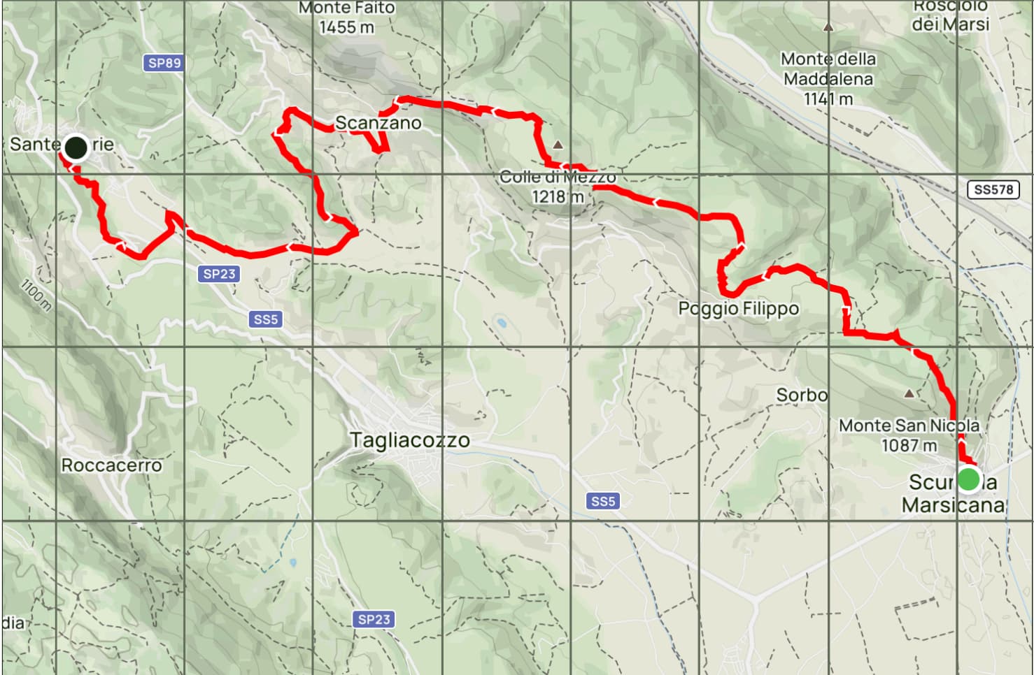
Da Scanzano il nostro Cammino intercetta il Sentiero Corradino (SC) che ci porterà da prima al più piccolo borgo del nostro cammino, Tubione con solo 3 residenti, e poi a San Giovanni , dove vale la pena visitare un piccolo gioiello di sacralità, la Chiesa di San Giovanni Battista, edificata nel XI secolo, ampliata nel 1756 e restaurata dopo il sisma del 1915. Ogni 24 giugno si celebrano le feste patronali di San Giovanni Battista.
Attraversato il borgo di San Giovanni ci incamminiamo su un comodo sentiero in leggera discesa, dopo circa 400 metri, oltrepassato il campo sportivo, al bivio gireremo a sinistra per portarci verso la pineta su un percorso in leggera salita attraversata la pineta, seguiremo il sentiero e scendiamo tra le abitazioni e seguendo la strada arriviamo al municipio di Sante Marie.

Characteristics of the Way
∙Number of Stages: 5
∙Distance: Approximately 80.0 km, with 3,504 m of elevation gain.
∙Travel Time: 5 days
∙Difficulty: Medium.
∙Environment: The stages pass through chestnut and beech forests, meadows, breathtaking views, and 10 villages.
The Grande Cammino della Brigantessa (Great Brigand’s Trail) is a fascinating 86 km route through the enchanting landscapes of Abruzzo, starting in Sante Marie (AQ) and passing through places rich in history and culture. With an elevation gain of 3,504 meters, this trail offers a unique experience immersed in nature and tradition.
The trail begins in Sante Marie, known as the town of the Cammino dei Briganti (Brigands’ Trail) and Murals. Here, visitors can admire works of art that tell stories of bandits and local life. From here, the trail heads towards Tremonti, the first town you encounter, where you can experience
local traditions.
Continuing, the trail enters the Luppa Caves Regional Nature Reserve, an area of extraordinary natural beauty. Here, you are surrounded by lush forests and breathtaking views, leading to Castelvecchio. This picturesque village, with its ancient walls and characteristic charm,
is an important stop on the route. Continuing, you come across the Brigands’ Path, which leads to Valdevarri, a place of great historical significance, as it was home to Thomas of Celano, the first biographer of Saint Francis. This village offers a reflective pause, immersed in history and spirituality.
From Valdevarri, the trail winds along paths and roads leading to the village of Santo Stefano. Here, hikers can prepare for the climb to Monte Faito, the highest point of the route, which rises to 1,410 meters. The view from the summit is spectacular, offering a panoramic view of the surroundings and a
sense of achievement.
After admiring the view, we descend towards the hamlet of Scanzano, which we pass through before heading towards Scurcola Marsicana. This town is known for its rich historical and cultural heritage, particularly for the Orsini Castle, which dominates the surrounding landscape.
Finally, from Scurcola Marsicana, the trail returns to Sante Marie through a long and evocative stage. Along the way, we pass through charming villages such as Tubione, the smallest town on the route with only three residents, and San Giovanni, from where we can admire the final destination.
The Great Brigantess Trail is not just a physical route, but a journey that explores the history, culture, and natural beauty of the region, uniting the traditions of the brigands with local spirituality and heritage.
Sante Marie – Sante Marie
First Stage
Stage Characteristics
∙Distance: Approximately 18.9 km, with 829 m of elevation gain.
∙Travel Time: Estimated between 6:30 and 6:45 hours, depending on stops and walking pace.
∙Difficulty: Medium, with challenging uphill sections.
∙Environment: The stage passes through chestnut and beech forests, meadows, and breathtaking views.
This first leg of the route begins in Piazza Aldo Moro, directly in front of the mural dedicated to the female bandit Nicolina De Cesare. It winds for about three hundred meters along Via Roma, where you can admire a series of murals depicting folk-style artworks, representing icons of history, traditions, and scenes of rural life, as well as evoking the theme of banditry in Abruzzo.
After admiring these beautiful murals, we continue our walk, turning slightly right onto Via della Resistenza, which we leave after about a hundred meters. At the crossroads, we turn right onto Via Boccavalle, until we reach a clearing with a cross on the right, which offers a magnificent view of the village of Sante Marie.
Continuing, we reach a fork with the Corradino Trail, where we turn left; a gentle slope leads us to a dirt road nestled in a chestnut grove. After passing a house on the left, we come to a fork where we turn left again. After passing more houses under construction, we join the “singol trek” trail that will take us to the residential center known as the Piccole Dolomiti.
After passing some houses, we turn right and follow the dirt road following the signs for the Cammino, which overlaps with the San Quirico trail.
This section winds through the Luppa Caves Regional Nature Reserve until reaching the little church of San Quirico, a true rock gem immersed in nature and dedicated to the patron saint of Sante Marie. But the surprises don’t end there: the trail continues towards the “Giant Bench,” from which you can admire unique views of the mountains of the Sirente-Velino Regional Park and the Duchessa Nature Reserve, all the way to the mountains of the Abruzzo National Park on the horizon.
Continuing, we reach the “Chiesetta degli Alpini” (Alpini Church) and, after about 1.5 km, we reach the medieval village of Tremonti, where we’ll make a brief stop to replenish our water supplies. From Tremonti, following the signs, we head through beautiful meadows and thick woods toward the “Fonte della Rocca,” where we can enjoy a refreshing break at the picnic area of the Grotte di Luppa Regional Reserve.
Next, along a charming singletrack trail, we reach the Grotta di Luppa. From here, we return along the same route to the junction with the path that will lead us to the “Grotta del Tesoro,” before returning to the Fonte della Rocca and finally continuing to Sante Marie, where the first stage concludes.
Sante Marie – Santo Stefano
Second Stage
Stage Characteristics
∙Distance: Approximately 17.2 km, with 723 m of elevation gain.
∙Travel Time: Estimated between 5:15 and 5:30 minutes, depending on stops and walking pace.
∙Difficulty: Medium, with challenging uphill sections.
∙Environment: The stage passes through chestnut and beech forests, meadows, and breathtaking views.
We begin, as in the first stage, from Piazza Aldo Moro, in front of the mural dedicated to the female bandit Nicolina De Cesare, the symbol of this Camino. From here, we take Via della Resistenza and, after about 150 meters, at the crossroads, we turn right onto Via Boccavalle until we reach a clearing with an iron cross on our right, from which we can admire a beautiful view of the village of Sante Marie and the valley below.
Immediately after, we reach the crossroads with the Sentiero Corradino, where we turn right and join the Sentiero Corradino until we reach the center of Castelvecchio, a hamlet of Sante Marie.
Castelvecchio’s origins date back to ancient times, and the village boasts a rich and fascinating history, influenced by its strategic location in the heart of the Apennines.
The area is known for settlements dating back to Roman times, but Castelvecchio developed primarily during the Middle Ages, a period in which numerous fortifications and castles were built to defend against invasions and conflicts. The name “Castelvecchio” suggests the presence of a fortified structure, used as a control point and protection for the local inhabitants.
Over the centuries, the village has retained its medieval charm, with narrow streets and stone houses that tell the story of the community. The main church, dedicated to St. John the Baptist, is an example of the region’s typical religious architecture. Castelvecchio’s hilltop location also offers splendid views and opportunities for various outdoor activities, such as hiking and walking in the surrounding nature.
Among the local events, the Castelvecchio Porcini Mushroom Festival, organized in mid-August by the local Pro Loco, is worth mentioning.
After passing through Castelvecchio, we continue for about 1.5 km on a paved road, Via Fontanile, which we then leave to turn right, following a fantastic path that winds through chestnut and beech woods, offering breathtaking views until reaching the center of Valdevarri, a hamlet in the municipality of Sante Marie.
This place has a significant historical connection with Blessed Thomas of Celano, an important 13th-century religious figure and writer. Thomas lived and died in the Poor Clares convent of Valdevarri, which is one of the places where he spent the last years of his life, dedicating himself to prayer and writing.
Founded in the 13th century, the Poor Clares convent is an example of religious architecture and monastic life. Here, Thomas wrote some of his most important works and continued to spread the message of Saint Francis. His death, around 1260, marked the end of a crucial figure in Franciscanism, fundamental to the spread of the spirituality of Saint Francis.
In Valdevarri, you can stop for refreshments and refill your water supply at the village fountain. Continuing our journey towards Santo Stefano, we take the road used only by residents, Via Valdevarri, for 1.5 km, then take the path on the left that, after about 4 km, will lead us to the end of the second stage in Santo Stefano.
Santo Stefano-Monte Faito-Scanzano
Third Stage
Stage Characteristics
∙Distance: Approximately 9.8 km, and 600 m of elevation gain.
∙Travel Time: Estimated between 4:15 and 4:45 minutes, depending on stops and walking pace.
∙Difficulty: Medium, with challenging climbs up to Monte Faito, 1,455 m. Descents through meadows and across paths.
∙Environment: The stage passes through beech forests, meadows, and breathtaking views.
The third stage of the hike, featuring the ascent of Monte Faito, offers a thrilling experience for nature lovers and hikers.
At 1,455 meters, it is the highest peak on the trail. Monte Faito offers breathtaking views that extend across the entire Abruzzo Apennines. During the ascent, hikers can enjoy a diverse landscape, with beech forests, flower-filled meadows, and the chance to spot local wildlife. The tranquility and beauty of the trail make this stage special, allowing you to fully immerse yourself in nature.
Once you reach the summit, the views are extraordinary: you can see the peaks of the surrounding mountains, Mount Velino, Mount Terminillo in the distance, not to mention the Maiella, the mountains of the Abruzzo and Molise National Park, and the Simbruini Mountains.
The panoramic view is a moment of great satisfaction for hikers, who can reflect on the journey and the effort they’ve put in. Furthermore, Mount Faito has historical and cultural significance, being a place of passage and reference for the locals. It’s also an excellent spot for taking photographs, collecting memories, and appreciating the natural beauty of Abruzzo.
Coming to the route, we leave the village of Santo Stefano, whose territory boasts a rich history dating back to pre-Roman and Roman times, when it was inhabited by the Aequi.
The mountain village known as Le Colonnelle was one of the boundaries of the Albensi, documented by a stone inscribed “Albensium fines,” found in the nearby Val de’ Varri and preserved in the church of Santa Maria in Scanzano.
The first historical records of the modern settlement date back to 1188, when Pope Clement III mentioned the “ecclesia Sancti Stephani in Caprili” in his papal bull addressed to Bishop Eliano, highlighting the presence of a church connected to a Benedictine monastery.
Even after the disappearance of the religious, this church remained a symbol of monastic life and formed the nucleus around which the first modern settlements developed, giving rise to the toponym “Santo Stefano.” This historical and cultural heritage represents a significant part of the local tradition and the history of the region.
After crossing the center of Santo Stefano, on the paved road, we arrive in front of the village cemetery. Here, we take the path on the left that leads to the archaeological excavations of Scanzano. Before reaching these, on our left, we take the path halfway up the hill that will take us to the intersection of a dirt road. At this point, we turn right, following the signs, which, through clearings and beech woods, will lead us to the summit of Monte Faito, marked by a large iron cross.
From here, we’ll take the obvious path that will lead us to the junction with the dirt road coming from San Donato di Tagliacozzo. We’ll turn right and, after a steep descent, we’ll reach the end of our third stage in the center of Scanzano.
Scanzano – Scurcola Marsicana
Stage Four
From the center of Scanzano, following the route signs and overlapping with the Cammino dei Briganti (Brigands’ Path), which we’ll leave on our right as soon as we reach the first fork (about 1 km), where we’ll find our sign. We descend on an easy path towards the town of San Donato. Immediately after the 3rd kilometer, we’ll turn slightly right and take a paved road for 800 meters (Via Aldo Moro), which will take us through San Donato. We’ll leave this road by turning right onto a dirt road (Via Nazzario Sauro), which we’ll leave after about 200 meters, turning left. We’ll follow Provincial Road 89 for about 800 meters until the fork with a path that we’ll take on our left. We’ll follow this path to Scurcola Marsicana, skirting the hamlet of Poggio Filippo at the 6th kilometer, and then continuing to the center of Scurcola Marsicana where the 4th stage of the Camino ends.
Stage Characteristics
∙Distance: Approximately 11.8 km, with 409 m of elevation gain.
∙Time: Estimated between 4:00 and 4:30 hours, depending on stops and walking pace.
∙Difficulty: The route is considered medium difficulty, with both paved and dirt sections.
∙Environment: The stage passes through chestnut and beech forests, meadows, and breathtaking views.
Places of Interest: This stage includes several places of interest, especially in the municipality of Scurcola Marsicana. These include:
Church of the Holy Trinity: This mother church is famous for its baroque staircase. The interior is decorated with local artwork and offers a deeply spiritual atmosphere.
Church of Santa Maria della Vittoria: In addition to the statue of the Madonna della Vittoria, the church is an important example of medieval religious architecture. It is a highly revered place of worship for locals, especially during religious holidays.
Rocca Orsini: A Renaissance fortress with a distinctive triangular shape.
Scurcola Marsicana – Sante Marie
Fifth Stage
Stage Characteristics
∙Distance: Approximately 23.1 km, with 943 m of elevation gain.
∙Time: Estimated between 7:30 and 7:45 minutes, depending on stops and walking pace.
∙Difficulty: Challenging, with challenging uphill sections.
∙Environment: The stage passes through the town of Scurcola Marsicana, pine forests, grassy areas, and breathtaking views.
This stage starts from the center of Scurcola Marsicana, Church of the Holy Trinity, crosses part of Corso Emanuele III, to take the first flight of steps on the left and climb up through the historic streets of the old town until reaching the Orsini Castle or Rocca Orsini from which we will not follow the path that leads to Monte San Nicola, but we will take the comfortable and panoramic dirt road on the right until reaching its peak inside a fantastic pine forest. At this point we take a left and follow a forest road inside the reforestation pine forest and cross it all to come out on a path on meadows until we cross the third path (540D) on our right which we take until we reach the village of Poggio Filippo which we will leave at the cemetery to take on our left, where we cross the path of the Cammino dei Briganti (CdB) up to Scanzano.
From Scanzano, our walk intersects with the Corradino Trail (SC), which will take us first to the smallest village on our route, Tubione, with only three residents, and then to San Giovanni, where a small sacred gem is worth visiting: the Church of San Giovanni Battista, built in the 11th century, enlarged in 1756, and restored after the 1915 earthquake. The patron saint’s day, San Giovanni Battista, is celebrated every June 24th.
After crossing the village of San Giovanni, we walk along an easy, slightly downhill path. After about 400 meters, past the sports field, we turn left at the crossroads to head towards the pine forest. After crossing the pine forest, we follow the path and descend among the houses. Following the road, we arrive at the town hall of Sante Marie.
